Beneath the Surface: How Arizona's Water Agencies Are Using Professional Photography to Make Hidden Infrastructure Visible
Water is Arizona's most consequential resource, yet the systems that move, treat, and monitor it remain almost entirely out of public view. Buried pipelines, subterranean aquifer monitoring wells, sprawling canal networks, and cavernous treatment facilities operate in perpetual anonymity—understood by engineers, largely invisible to everyone else. For Arizona's water management districts, that invisibility is not merely inconvenient. It is a genuine obstacle to public understanding, policy support, and the funding appropriations that keep critical infrastructure operational.
Specialized professional photography is quietly changing that dynamic. Across the state, water agencies are commissioning photographers with technical expertise to document, interpret, and ultimately humanize infrastructure that most Arizonans will never directly encounter. The result is a body of visual work that transforms abstract resource management into narratives that legislators, ratepayers, and community stakeholders can actually comprehend.
The Problem With Invisible Systems
Public agencies face a communication paradox that private businesses rarely encounter. A brewery can photograph its taproom. A jeweler can arrange its finest pieces under a macro lens. But how does a water authority communicate the significance of a pressure monitoring station buried beneath a Phoenix suburb, or convey the complexity of a groundwater recharge basin that looks, to the untrained eye, like an unremarkable desert pond?
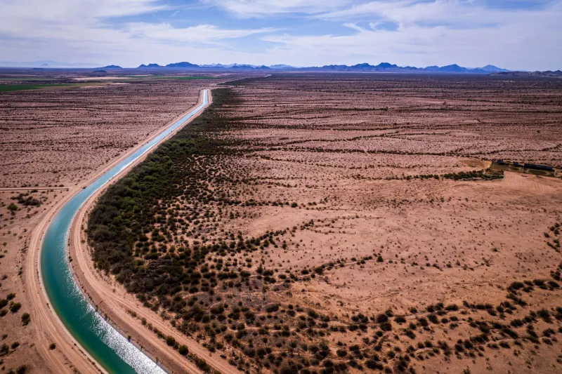
The answer lies in purposeful visual strategy. When the Salt River Project or the Central Arizona Project needs to present its stewardship case to the Arizona Legislature, or when a municipal water authority launches a rate-increase campaign to fund aging infrastructure replacement, photography becomes the most persuasive medium available. A well-composed image of a technician descending into a valve vault, or an aerial photograph revealing the full geometric scope of a canal network threading through the Sonoran Desert, communicates scale and complexity in ways that engineering reports simply cannot.
This is not decorative photography. It is precision communication work, and it demands photographers who understand both the technical environment and the strategic intent behind each image.
Technical Demands of Infrastructure Photography
Photographing water infrastructure presents challenges that distinguish this specialty from virtually every other commercial genre. Treatment facilities combine harsh industrial lighting with chemically sensitive environments. Confined spaces—pump stations, underground vaults, inspection tunnels—require photographers to work with portable lighting systems while navigating genuine safety protocols. Aquifer monitoring sites often exist in remote desert locations where natural light is intense, shadows are extreme, and dust presents constant equipment risks.
Aerial photography, frequently employed to document canal systems and reservoir infrastructure, requires coordination with aviation specialists and, in many cases, FAA compliance for drone operations over regulated airspace. The Central Arizona Canal alone stretches more than 330 miles, and capturing its relationship to the surrounding landscape—from the agricultural corridors of Pinal County to the urban density of Maricopa County—demands both technical planning and compositional sophistication.
Inside laboratory and monitoring environments, photographers must balance the clinical precision required for technical documentation with the visual warmth that makes public-facing materials engaging. A water quality analyst examining samples under fluorescent light can be photographed as a bureaucratic function or as a compelling portrait of professional stewardship. The distinction lies entirely in the photographer's approach to composition, depth of field, and the relationship between subject and environment.
Translating Data Into Visual Narrative
One of the more demanding assignments in water agency photography involves visualizing data—not charts or graphs, but the physical manifestations of environmental monitoring. Piezometer arrays, soil moisture sensors, and surface water gauges are inherently unglamorous objects. Yet they represent the measurement backbone of Arizona's groundwater management framework, and communicating their importance to non-specialist audiences is a legitimate institutional priority.
Experienced photographers approach these assignments by anchoring technical objects within their environmental context. A monitoring well photographed in isolation reads as industrial hardware. The same well photographed at dawn with the McDowell Mountains in the background, a hydrologist recording data in the foreground, becomes a statement about the intersection of science and landscape stewardship. That contextual framing is not manipulation—it is honest storytelling that accurately conveys why the work matters.
Water agencies have found that this kind of imagery performs exceptionally well in public meetings, annual reports, and grant applications. When the Maricopa Association of Governments presents regional water security planning documents, photographs that make infrastructure tangible consistently generate stronger engagement from elected officials and community members than technical diagrams alone.
Funding, Trust, and the Visual Case
Arizona's water infrastructure faces a capital investment challenge that will define the state's growth capacity for decades. Aging concrete-lined canals require rehabilitation. Groundwater replenishment programs need expanded recharge basins. Treatment facilities serving rapidly growing communities in the East Valley and along the I-10 corridor require significant upgrades to meet both population demand and evolving federal water quality standards.
Securing the funding for these projects—whether through legislative appropriations, federal infrastructure grants, or ratepayer-supported bond measures—requires agencies to make a compelling public case. Professional photography is increasingly central to that effort. Documentary series chronicling infrastructure rehabilitation projects, before-and-after visual records of recharge facility expansions, and photographic profiles of the workforce maintaining these systems all contribute to a cumulative narrative of responsible stewardship.
The Arizona Department of Water Resources, which administers the state's groundwater management framework, has recognized that public confidence in water security is itself a resource that must be cultivated. Visual documentation of the agency's monitoring and enforcement activities provides citizens with evidence that the systems protecting their water supply are actively managed by competent professionals—a message that no policy document delivers as effectively as a well-executed photograph.
Building a Visual Archive for the Long Term
Beyond immediate communications applications, water agencies are increasingly commissioning photography as long-term institutional documentation. Infrastructure built in the 1970s and 1980s is now approaching the end of its design life, and comprehensive photographic records serve multiple purposes: they support engineering assessments, inform rehabilitation planning, and create historical archives that document how Arizona's water systems evolved to meet the demands of a growing desert state.
For photography practices specializing in this domain, the work requires a genuine commitment to understanding the subject matter. Effective water infrastructure photography is not simply a matter of technical camera competency—it demands that the photographer understand what they are documenting, why it matters, and how the resulting images will serve the agency's mission over time.
Arizona's water story is one of extraordinary engineering ambition meeting the realities of an arid environment. The professionals who photograph that story are contributing to a visual record that will inform public understanding long after the current infrastructure debates are resolved. That is work of genuine consequence, and it deserves the precision and intentionality that specialized photography brings to every other domain where complexity demands clarity.